

Operational AI on an Australian Farm: Weather Guidance and Livestock Movement
INTRODUCTION
On a third-generation grazing property in rural New South Wales, the daily challenge isn’t “AI transformation” — it’s whether to move sheep before frost, or keep cattle shaded and watered on a 35 °C day.
Most “AI in agriculture” stories talk about drones, sensors, or blockchain supply chains. This build took a different path: built from a CSV paddock register, Bureau of Meteorology data, and a lightweight Python script.
The goal was simple: generate clear, timely guidance on stock movement that a non-technical grazier could actually use — delivered as a text message or a Teams card, not a glossy dashboard.
Key themes
Responsible AI in Practice — decisions shaped by weather and operator context; AI used for natural phrasing
Design for Constraints — low connectivity, non-technical audience, volatile weather.
Operational Augmentation — support decisions without replacing human judgement.
Method
Classified paddocks via CSV (gully, ridge, flat, dams, shelterbelts, troughs).
Pulled BoM forecasts for the farm centroid.
Used a Python rules engine to flag frost, heat, wind, and rain risks.
Generated deterministic stock movement guidance (always-on).
Layered optional AI phrasing (GPT-5) to render outputs in plain, non-technical terms.
Principle
You don’t need dashboards or hype to apply AI responsibly. You need logic, context, and outputs that match the operator’s reality.
Lay of the Land
A third-generation grazing property in rural New South Wales faces frequent weather extremes — frost, heat, fire-driven storms, and strong winds — requiring regular movement of sheep and cattle.
Farm Area: ~6.4 km² with gullies, ridges, flats, dams, and shelterbelts.
BoM forecasts cover a district (≈255 km²) — too broad to guide paddock-level moves.
Local variation matters — a gully can sit 2 °C colder than a ridge before dawn.
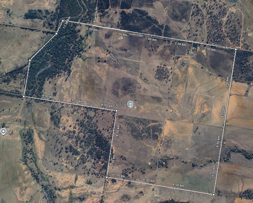
Google Maps outline used to measure farm size.
Method:
Used Google Maps for an aerial view of the farm.
Marked farm-centre coordinates for forecast alignment.
Outlined boundary fences, shelterbelts, and dams.
Mapping the terrain
Each paddock was tagged according to its terrain and features, ensuring the rules engine could link weather risks to the right parts of the property.
To ground the rules engine, paddocks were classified by terrain type and features:
Gullies (low country): colder, prone to frost.
Ridges (high country): exposed to wind.
Flats (open country): risk of heat stress and runoff.
Dams & troughs: critical water access during heat.
Shelterbelts: protection from wind and sun.
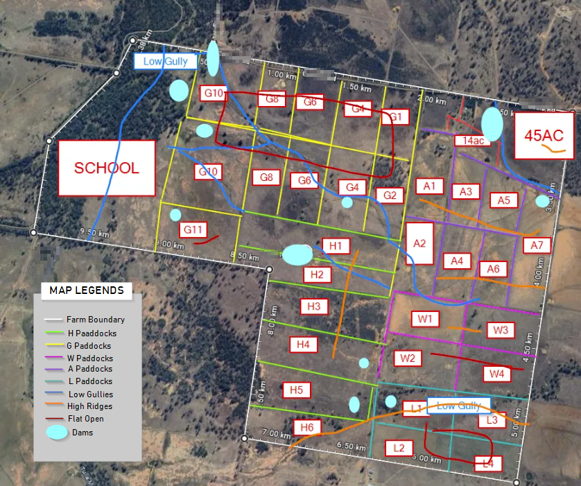
Marked map with terrain classification.
I didn’t sign up for this!!
What began as a test quickly turned into a marathon. The aim was clear — pull Bureau of Meteorology forecasts and deliver usable guidance into Teams — but the path there was anything but smooth.
Test script (success): Confirmed OpenAI + Teams integration worked end-to-end.
Per-paddock forecasts (abandoned): Planned to fetch weather for each paddock, but dropped it — readings didn’t vary and reliability was questionable.
Centre-point anchor: Shifted to a single centroid forecast for all paddocks.
Six-hour Python spiral: Hours disappeared into half-working scripts. Outputs scrambled, formatting broke, and no one signed up for a crash course in Python.
BoM ADFD pulls: Integrated real Bureau of Meteorology data into the pipeline.
More crying (and rescue): At peak frustration (crying emojis included), the code was restructured from scratch. Within 10 minutes, the Teams output was finally clean and consistent.

Frustration vs Pragamatic Pivot.

The initial output was cluttered and difficult to read.

Final output: polished and easy to read at a glance.
Principle
Progress is rarely linear. Useful builds don’t come from a single clean script, but from testing, breaking, and reworking until the outputs are stable enough to trust.
Wrap-Up
This project began as a family build — a way to make weather forecasts more practical for stock movement on a 6.4 km² grazing property in rural New South Wales.
It also reflects the spirit of OpenAI’s Economic Blueprint for Australia — a vision where AI drives productivity and resilience in everyday settings, not just high-tech labs or smart cities. We took a national-scale goal — better outcomes for rural, connected-by-SMS operations — and turned it into a working example.
The lesson is simple: the economic lift AI promises won’t come from drones or dashboards. It will come from grounded, accessible logic, layered into the systems people already use.
Principle
AI earns its place when it supports decisions, not replaces them.